


240607 - Lacs pas des ondes

randodan
User
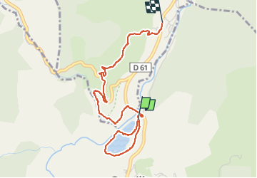

Length
3.8 km

Max alt
616 m

Uphill gradient
105 m
Km-Effort
5.1 km

Min alt
512 m

Downhill gradient
90 m
Boucle
No
Creation date :
2024-06-07 07:50:58.097
Updated on :
2024-06-07 09:52:04.367
2h00
Difficulty : Difficult

FREE GPS app for hiking
 SityTrail
IGN / Geographical institutes
SityTrail Plus
The world is yours!
About
Trail Walking of 3.8 km to be discovered at Auvergne-Rhône-Alpes, Drôme, La Motte-Chalancon. This trail is proposed by randodan.
Description
descente mortelle
Positioning
Country:
France
Region :
Auvergne-Rhône-Alpes
Department/Province :
Drôme
Municipality :
La Motte-Chalancon
Location:
Unknown
Start:(Dec)
Start:(UTM)
688378 ; 4926199 (31T) N.
Comments